Geospatial data is complex and multi-dimensional.

Over the years, as I have worked with non-GIS experts, I have come to the realisation that spatial data, due to its complexity is one of the hardest parts about learning GIS. New GIS users often struggle with spatial data due to the many characteristics and multi-dimensionality associated with data as well as the volume of data.
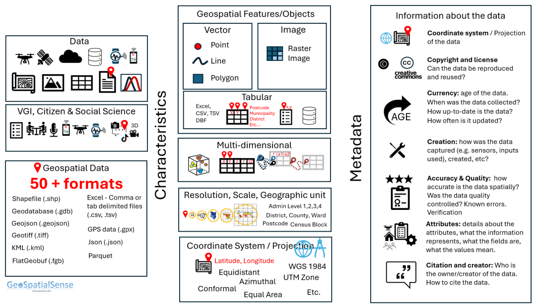
To help capture these complexities I have tried to provide an overview of the different elements associated with spatial data that include the many characteristics and information (metadata) about the data:
Overview of data
- Data can come from a variety of sources.
- Data comes in various forms
- Data is stored in a variety of formats. Some of which are driven by vendor specific formats. New formats are continually being developed.
Data Characteristics
- Data objects or features can be represented as a vector, image (raster, grid, pixel) or a table (spreadsheet).
- Data attributes can be numeric, text, date, time.
- Data can be multi-dimensional capturing features in space and time
- Data objects can have multiple relationships with information that can be represented as a one-many relationship or a one-one or a many to one relationship.
- Data can be stored at different scales and resolutions.
- Data can be captured or stored in different coordinate systems.
Metadata (information about the data)
- Data should be accompanied by metadata so that it is possible to understand how the data was created, what data sources were used and if there are any limitations in its reuse etc.
As you can see, there are many elements associated with geospatial data where each feature is linked to further data or attributes that are often stored in a spreadsheet.
To learn more watch these videos
And if you are interested in making data mappable then watch these 2 videos. Here is Part 1 of making data mappable.
Here is Part 2 of making data mappable.
