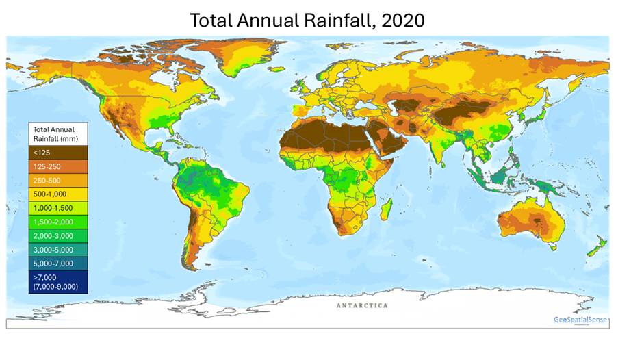
Have you ever wondered how much it rains in different parts of the world? Where does it rain the most? Where does it rain the least? We were also curious so we created two maps using global monthly rainfall data from 2020.
For the total annual rainfall map we added all of the rainfall for each month from January 2020 to December 2020. For the average annual rainfall we then divided the total annual rainfall by the number of months (N=12) to create average rainfall around the world. The two maps capture where rainfall is high and where it is low. The average rainfall map further accentuates the low rainfall areas.

As you can see there are many parts of the world that receive less than 30 mm of rainfall on average per month.
Mapping deserts around the world
Finally, we created a map of deserts around the world based on total annual rainfall. In this case we defined a desert as a location where the total annual precipitation is less 250mm. Based on this definition we extracted areas where total annual precipitation is less than 250mm and created a global map of deserts.

We identified several deserts around the world. These include subtropical, coastal, cold and polar deserts.
Have a look at the map. Are there any deserts that you did not know about? Can you classify these deserts into subtropical, coastal, cold or polar? Interested in learning more about the different deserts look at list of deserts provided here: https://en.wikipedia.org/wiki/List_of_deserts_by_area
© 2023-present GeoSpatialSense. All Rights Reserved

One thought on “Where are all of the world’s deserts?”
Comments are closed.