
Surprisingly after 20 years of having a career in the GIS field, GIS is still very much a discovery field, yet GIS is used across a wide range of disciplines and in just about every sector or industry.
No doubt you are using some form of geographic information every day. How often do you check a map and for what? Might it be for planning a trip or finding the best route to a new destination?
- Routing and destinations. figuring out how to get somewhere – what route to take, how to get to a destination from your current location using different modes of transport – walking, by car or public transport (e.g. train or bus) and how long it will take you to get to your destination.
- Weather forecasts. checking the weather forecast in your local area. Depending on where you live you may want to check the weather radar (now available on many weather apps or websites) to see when it will rain, for how long and the intensity of the rain (will it be heavy or light rain). In the Netherlands, a country where mostly everyone cycles, it is common to check a weather app and plan your trips around the rain!
- Planning for a trip. planning a holiday? No doubt you have checked a map while planning a trip to a new city or country. You may be interested in figuring out what to see (e.g. tourist attractions, museums, buildings, statues and other points of interest (POI’s)) or even where to stay (e.g., hotels, bed and breakfasts, etc.) or eat (e.g. restaurants, super markets, café’s and bars). Knowing where these are will help you plan your trip and how you will get around (walking, biking, public/private transportation).
- Social Media. posting a message on social media with information about what you are doing where. While posting you may include some type of geographic information such as gps data (latitude and longitude) or the name of a place (city, country) to your post. This will help you (and others) place your information on a map.
These are only a few small examples of how you might use this information. However, for you to be able to search for information, see the information or combine information requires skills of a Spatial Data Scientist.
According to a report by GeoSpatial World “80% of all the data in the world has a spatial relation”. In reality just about all data today is spatial and has some form of spatial information attached or embedded.
In a report from the UK where they analyzed a variety of job descriptions over a 5 year period, six main industries emerged. These included GIS specialists, Programmer & Data Management, Robotics & SLAM, Civil Engineers, Surveyors and Other.
The types of skills listed for each of these industries include
- proficiency in GIS software (e.g. ArcGIS & QGIS)
- proficiency in spatial methods
- image analysis skills (from processing to feature and information extraction for scene understanding and rendering)
- data science skills for dealing with different types of data of varying quality, quantity and availability (think of the 5 V’s – velocity, volume, value, variety and veracity and beyond for other characteristics associated with data)
- programming and design (application development, methodological developments, architecture and design, software engineering)
- analytics (making the information accessible through static or interactive visualisations)
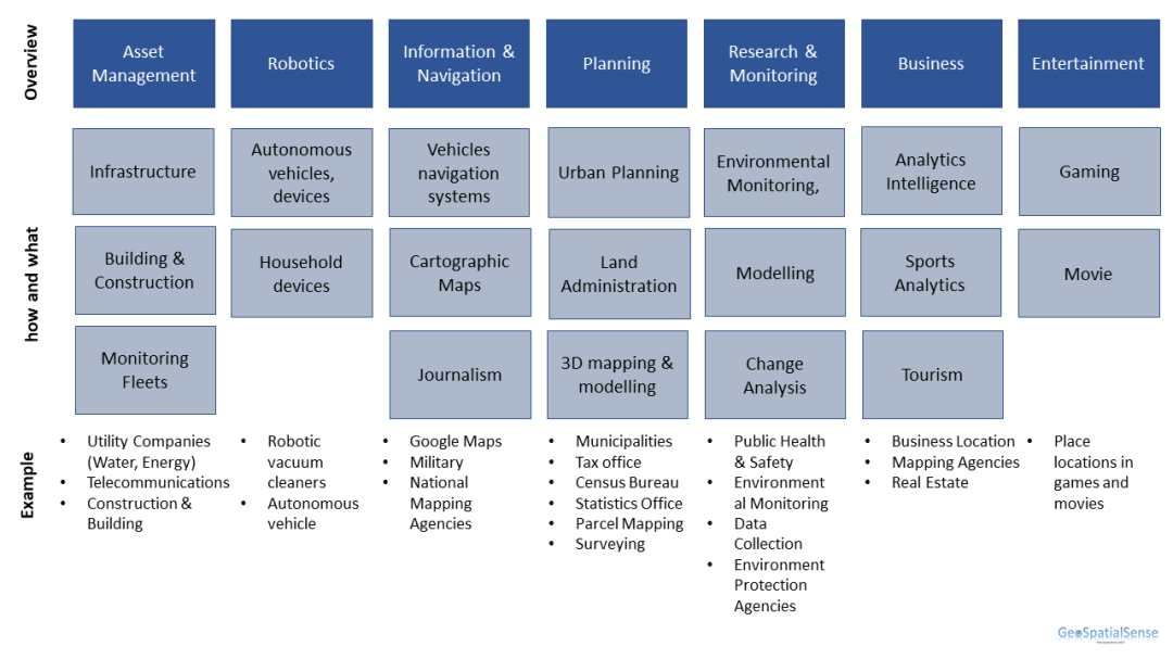
If you are interested in a career in this field here are some examples. This is by no way complete but will give you some ideas of the range of industries that are using geospatial information and technologies.
Summary
In summary, the technical skills you gain as a GIS expert or spatial data scientist will serve you well and provide you with a variety of opportunities based on your interests (health, agriculture & food security, climate change, protecting the environment, conservation, tourism, planning, business needs, etc.). The technical skills or geospatial competencies can range from data creation to analytics and involve GIS analysis to complex simulations or the development of algorithms and applications. Where you end up in this field is up to you and your interests!
Sources:
Geospatial World – https://www.geospatialworld.net/prime/business-and-industry-trends/geospatial-industry-skill-gap-ways-to-build-the-best-workforce-2/
https://www.geospatialworld.net/consulting/gki-phase-2/gw-assets/pdf/GKI-Report.pdf
UK Report – UK Geospatial Strategy (2020)
